Rising more than 5,000 metres (about 16,000 feet) above sea level, the Rwenzori Mountains stand among Africa’s most dramatic and mysterious landscapes. Straddling the border between Uganda and the Democratic Republic of Congo, these towering peaks dominate the western branch of the East African Rift.
When clouds part, they can be seen from miles away—some reports even suggest they are visible from space. More often, however, thick mist and prolonged rainy seasons cloak them in secrecy, limiting visibility and adding to their mystique.
A rare, nearly cloud-free image captured by the Landsat 9 satellite on March 13, 2024, offered one of the clearest natural-colour views of the Rwenzori in years.
The image highlights the unusual geological origins of the range. Unlike Mount Kilimanjaro or Mount Kenya, the Rwenzori are not volcanic. Instead, powerful tectonic forces have slowly pulled the Earth’s crust apart, causing some blocks to sink while others—like the Rwenzori—were thrust upward over millions of years.
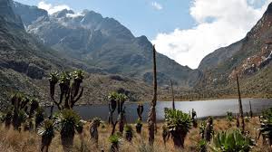
Beyond their imposing height, the Rwenzori Mountains are a treasure trove of biodiversity and history. Designated a national park in 1991 and recognized as a UNESCO World Heritage Site in 1994, the region supports plant life found nowhere else on Earth.
Giant lobelias and towering groundsels give the landscape an almost otherworldly appearance. Dense forests shelter African forest elephants, eastern chimpanzees, and elusive Rwenzori duikers.
The mountains are also a critical source of water. Numerous streams and rivers originate here, including the Semliki and Nyamwamba, eventually feeding into Lake Albert and Lake George.
This hydrological importance explains why the ancient Greek astronomer Ptolemy referred to the Rwenzori as the “Mountains of the Moon” nearly 2,000 years ago. He believed their snow-fed waters were the source of the Nile—a theory now known to be oversimplified, though the mountains remain vital to regional water systems.
At the heart of the range stand its three highest peaks, long crowned with snow and ice. Mount Stanley, the tallest, still hosts a mix of snowfields and glaciers. However, scientific observations reveal a troubling trend.
Between 2020 and 2024, the Stanley Plateau glacier is estimated to have shrunk by nearly 30 percent. Nearby Mount Speke has reportedly lost its glacier entirely.
These glaciers exist not because of latitude—after all, the Rwenzori lie near the equator—but because of extreme elevation. Yet rising global temperatures are eroding this fragile balance.
As warming accelerates, glaciers are thinning, retreating, and in some cases becoming stagnant ice fields that no longer flow.
The Rwenzori are not alone in this decline. Across East Africa, ice is disappearing at alarming rates. Mount Kilimanjaro and Mount Kenya show similar patterns, echoing losses seen in other tropical mountain regions such as Indonesia’s Puncak Jaya and Venezuela’s Sierra Nevada de Mérida. What remains of these glaciers appears increasingly delicate and vulnerable.
From a distance, the snow-capped peaks still look majestic. Up close, scientists see shrinking ice, exposed rock, and warning signs of long-term change. The consequences extend beyond scenery.
The Rwenzori’s glaciers help regulate water flow for ecosystems and communities downstream, and their retreat may disrupt rivers that millions of people depend on. Experts caution that local populations are likely to feel the impact first.
The Rwenzori Mountains embody a convergence of geology, ecology, history, and human reliance. They tell a story that stretches from ancient astronomy to modern climate science.
Despite mounting environmental pressures, they continue to dominate the landscape—powerful, awe-inspiring, and increasingly fragile reminders of a changing planet.