The Kenya Meteorological Department (KMD) has issued a weather advisory warning of heavy rainfall, strong winds, and rough seas along parts of the Kenyan coast as a tropical system — named Tropical Storm Chenge — moves westward across the northern Mozambique Channel.
In a statement released on Sunday, KMD said the system, currently described as the “Chenge residual depression,” is an area of low atmospheric pressure located about 500 kilometers north of Madagascar.
It is moving westward at approximately 11 km/h, with sustained winds of 55 km/h and gusts reaching up to 75 km/h, while maintaining a central pressure of around 1000 hPa.
Although the storm has continued to weaken over the weekend, its proximity to the Kenyan coastline may still influence local weather conditions, particularly over the southern coastal counties of Kwale, Mombasa, Kilifi, and Lamu, as well as parts of Taita Taveta.
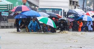
“Heavy rainfall is expected over several parts of the southern coast, with strong winds exceeding 25 knots likely on Monday and Tuesday as the system dissipates,” read the KMD statement in part.
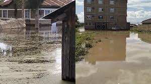
KMD has warned that the system may trigger localized flooding, rough sea conditions, and strong onshore winds, posing risks to marine operations, coastal settlements, and low-lying areas.
Residents living in flood-prone zones, fishermen, and those engaged in marine transport have been urged to exercise extreme caution, monitor official updates, and avoid venturing into the deep sea during the advisory period.
“We urge the public, especially those in coastal and marine areas, to remain alert and take the necessary preparedness measures. Safety must come first,” the department added.
Meteorologists say the weakening of Tropical Storm Chenge comes after it lost intensity as it traveled across the warm waters of the Indian Ocean toward the Mozambique Channel.
However, the system’s moisture and wind circulation patterns could still enhance rainfall activity not only along Kenya’s coast but also across northern Tanzania and parts of southeastern Kenya.
Weather analysts from the Intergovernmental Authority on Development (IGAD) Climate Prediction and Applications Centre (ICPAC) have also noted that tropical systems forming in the western Indian Ocean tend to influence short rainfall (October–December) patterns across East Africa.
KMD assured that it continues to closely monitor the evolution of the tropical depression in collaboration with regional and global meteorological centers. Further updates will be issued should the system intensify or shift direction.
The warning follows a series of heavy rainfall events recorded in recent weeks in parts of the Coast and Eastern regions, which have caused flash floods, disrupted transport, and affected farming activities.
Members of the public are encouraged to follow official channels, including KMD’s verified accounts and local media, for regular weather updates rather than relying on unverified online information.
Tropical Storm “Chenge” was named earlier this week after forming in the southwestern Indian Ocean basin. Such systems typically develop when warm ocean waters and moist air combine with unstable pressure patterns, generating powerful winds and heavy rainfall.
While most tropical storms in the region lose strength before reaching the East African mainland, their remnants often bring significant rainfall and coastal disturbances — similar to Cyclone Hidaya (2024) and Cyclone Jobo (2021), which both affected Kenya’s coastal weather systems.